From the Library - Len Mullenger
Ortelius History of the World
full website
here (French Edition)
 Abraham
Ortel (1527-1598) known simply as Ortelius.
Abraham
Ortel (1527-1598) known simply as Ortelius.
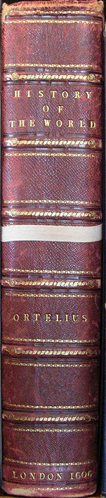
History of the World is one of a fine collection of rare books in
the Charlecote Library. Its correct title is Theatrum Orbis Terrarum
which translates as Theatre of the World. It is not a history
book but the first true Atlas, produced in 1570, although it does
contain some historical maps.. The Charlecote library has two copies.
There is a copy of the original 1570 print in Latin on vellum with
a reduced number of maps and 1606 English and most complete edition.
What we can see is actually a slipcase with the book inside. Although
Ortelius was himself a map-engraver he was highly regarded as a collector
of maps and the Theatrum is a presentation of maps from other sources.
Many of these sources have been lost and the names of the engravers
have been kept alive by the Ortelius collection. Ortelius redrew these
maps so as to present them to a standard size and orientation. For
the first time in one volume, all parts of the globe were treated
in a comprehensive and uniform manner, and thus it presented as complete
a picture as was then possible of the whole world.
The library card indicates there are some loose maps
with this book. The number of maps in the book grew from 53 in the
1570 edition to 119 map sheets and 36 historical, or classical, maps
by the 31st and last edition before the death of Ortelius. The book
was so popular in remained in print until 1612. In total there were
over 40 editions in seven different languages. In 1573 until 1579
Ortelius published supplementary maps in an Additamentum Theatri
Orbis Terrarum. These may be the additional maps referred to on
the library card. Over 7000 copies were sold in total comprising the
various editions.
The maps were not intended to provide just cartographical
information but were to be appreciated and desired as objects in their
own right. To this end the were often highly decorated and coloured.
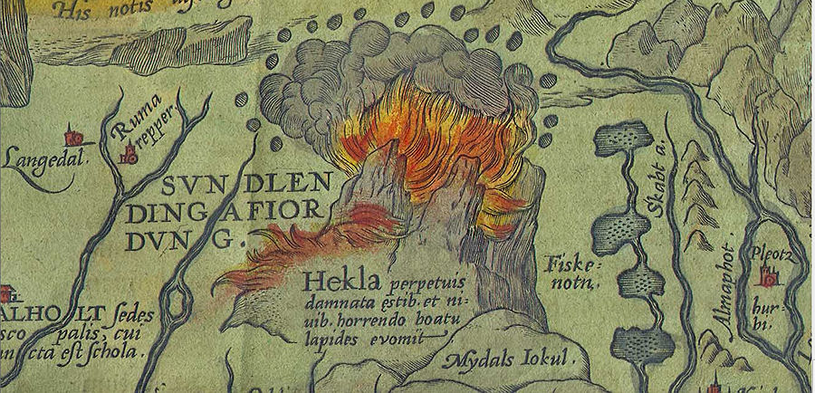
A fine example is his map of Iceland (Islandia) showing mountain ranges,
fjords, glaciers and the Mt Hekla volcano (larger
version). There are Polar Bears shown floating on Icebergs top
right (larger version) and in the seas
are a fine collection of Sea Monsters (the greatest number to be shown
on one map).
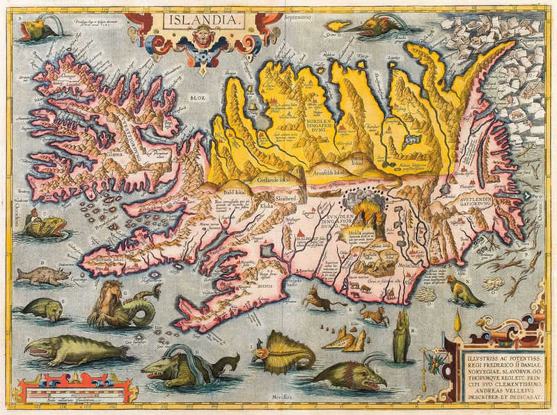
see
larger version here
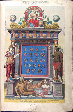 The
book has a highly decorated and finely detailed title page [colophon](left).The
two female figures either side of the arch represent Asia and Africa
with Europe seated at the top. At the bottom is a recumbent figure
holding up a decapitated head with her bow and poisoned arrows. This
is Ortelius' idea of the New World! Next to her is a female bust on
a pedestal above a flame which represents the Southern tip of South
America, Magellanica, which was not fully charted but many fires had
been sighted (hence Tierra del Fuego).
The
book has a highly decorated and finely detailed title page [colophon](left).The
two female figures either side of the arch represent Asia and Africa
with Europe seated at the top. At the bottom is a recumbent figure
holding up a decapitated head with her bow and poisoned arrows. This
is Ortelius' idea of the New World! Next to her is a female bust on
a pedestal above a flame which represents the Southern tip of South
America, Magellanica, which was not fully charted but many fires had
been sighted (hence Tierra del Fuego).
See
larger version here
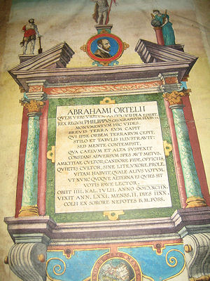
The 1606 version has a dedication to Ortelius (top
right) which translates as :
You see here the monument of Abraham Ortelius whom the city of
cities, Antwerp, brought forth.
The King of Kings, Philip, had him as geographer.
For a short time the earth held him who himself held the globe of
lands.
With his pen and writing tablets he illustrated it, yet he held it
cheaply, he who surveyed the heavens and the heights, unmoved by hope
or fear.
He was a lover of friendship, carried out his duties with radiant
good faith; he was also a lover of privacy, shunning disputation,
marriage and crowds.
He led his life as if he were dedicated elsewhere (i.e. to God).
Reader, pray that he may have rest now and evermore.
He died on the fourth day before the kalends of July in the year (June
28) 1598. (Roman reckoning included the kalends as day 1).
He lived 71 years, 2 months and 18 days.
(This monument) dedicated by his sister's sons to BM Poss. (Beata
Maria Possente? The powerful blessed Mary, though BMV is the more
usual abbreviation for Mary)
(with thanks to Brian Wilson for the translation)
Ortelius had two sisters and together they worked
as map colourists. He did not produce any maps of his own until in
his mid-thirties by which time he was much travelled and had made
connections with other historians, topographers and cartographers
who, when the time came, assisted him in compiling the Theatrum.
The world map from Theatrum Orbis Terrarum

See
larger version here
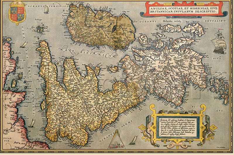
From 1573 onwards the Ortelius atlas contained maps
of England and Wales and of Wales alone by the Welsh historian and
topographer Humphrey Lhuyd. . In 1603 this was replaced a map of Christoper
Saxton which only lasted one edition to be replaced by one from Jan
Baptist Vrient who included Ireland and a genealogical table of the
Royal family. I assume this is the map in the Charlecote copy but
I show the Lhuyd and Vrient maps below.
Anglia Regni by Humphrey Lhuyd (1573)

see
larger version here
The Charlecote 1606 copy contains the follwing version:
Anglia et Hiberniae - Johan Baptist Vrient 1605
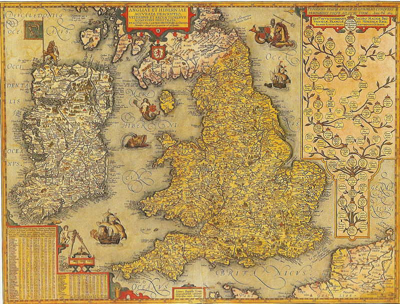
see
larger version here
However the Charlecote 1570 copy has adifferent map showing the UK
sideways on. I have not discovered who engraved that
Further information:
see
Wikipedia
Library
of Congress, Historical Collections for the National Digital Library,
Ortelius Atlas
High
resolution zoomable images from the 1574 edition - Collection
item from the State Library of Victoria
Len Mullenger is a Sunday volunteer guide. Any comments
are welcome and can be sent to len@musicweb-international.com
